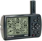
| The GPSMAP
196 is a versatile navigator for air,
land, and sea.
This WAAS-capable unit has detailed moving map
graphics, HSI steering guidance, a Jeppesen database,
and all the other pilot-friendly features you'd expect
from Garmin. You'll be amazed at the exceptional
resolution and contrast on this unit's 12-level
grayscale display, and its lightning-fast processor
makes for extremely fast map redraws and scrolling.
Situational awareness gets a boost from built-in land
detail that includes political boundaries, cities,
interstates, roads, rivers, and lakes. Steering guidance
is clearly presented through a graphic HSI with VNAV,
with extended runway centerlines to help orient you to
the runway. An automatic logbook also calculates your
flight time and automatically records departure and
arrival locations. When used with Garmin's free logbook
software FlightBook his feature makes light work of
maintaining your logbook. Your flight information will
be stored in the unit and can be downloaded to this
exclusive GPSMAP 196 Flightbook software at any time.
The GPSMAP 196 compromises nothing in its
versatility, going from cockpit to land to water. In
fact, it offers some of the same features found in
expensive in-dash car navigation systems, including auto
routing. In addition to the built-in Garmin basemap, the
GPSMAP 196 accepts most of our MapSource products.
Features include:
- Unique panel page graphically displays flight
information
- Logbook feature automatically records departure
airports, arrival airports, and flight time, all of
which can downloaded to free Flightbook software
- Extended runway centerlines display on a moving
map
- Split-screen moving map and HSI display
- Three distinct modes: Aviation, Land, and Water
- Turn-by-turn automotive routing
- Advanced scrolling feature reveals detailed
information when rolling the cursor over the
built-in basemap.
- Large (3.8-diagonal) 12-level grayscale display in
a slim package
- Fast processor provides map redraws and scrolling
at over twice the speed of previous aviation
portables
|