
| Garmin Handheld GPS | |||
| Garmin GPSMAP 696, 695, 196, 96c, aera 560, 550, 510 & 500 | |||
|
|
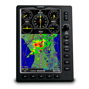 |
Garmin GPSMAP 696 The GPSMAP 696's bright 7" diagonal high-definition sunlight-readable display makes detailed mapping easy to see day or night — you can even view an entire approach plate on the large-format display. For easy operation, the bezel around the screen includes soft keys and a joystick control. And with a fast 5 Hz GPS update rate, the 696 renders graphics and presents flight data smoothly and continuously.
|
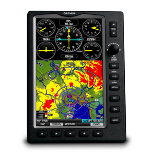 |
Garmin GPSMAP 695 The GPSMAP 695's bright 7" diagonal high-definition sunlight-readable display makes detailed mapping easy to see day or night — you can even view an entire approach plate on the large-format display. For easy operation, the bezel around the screen includes soft keys and a joystick control. And with a fast 5 Hz GPS update rate, the 695 renders graphics and presents flight data smoothly and continuously.
|
|
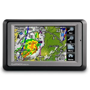
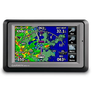
Garmin aera 560 The most feature-rich navigator in Garmin's aera lineup, the 560 model combines a more advanced list of automotive and piloting capabilities with higher-resolution 9 arc-second terrain/obstacle graphics that yield over 11 times more onscreen resolution than the standard 30 arc-second versions. As in all the aera models, GPS updating is provided at a super- fast 5 Hz rate. And you also get full support for the latest in XM WX™ satellite weather capabilities¹. With coverage for the U.S. and Canada, the XM service lets you reference detailed NEXRAD imaging and METARs data, as well as current reports on precipitation, lightning, winds aloft, airport terminal forecasts, and more. Weather graphics can be overlaid on your aera's moving-map display. And for added entertainment value, your XM receiver can also be used to access over 170 channels of digital audio entertainment (XM subscription required). The GXM 40 smart antenna is included with your aera 560. And a single integrated cabling solution for power, music and datalink weather options makes for easy, clutter-free aera connectivity in your cockpit |
|
Garmin aera 550 Stepping up from the aera 500 model, the aera 550 brings added features, performance, and more advanced pilot/motorist capabilities to the overall product design. Terrain/obstacles graphics are shown in higher-resolution 9 arc-second detail on the aera 550 display (providing over 11 times more onscreen resolution than the standard 30 arc-second versions). And, as in all the aera models, GPS updating is provided at a super-fast 5 Hz rate. In addition to detailed flight mapping, the aera 550 comes fully preloaded with Garmin SafeTaxi® charts for over 950 U.S. airports – while an included AOPA Airport Directory database gives you detailed listings, phone numbers, facilities and fuel location information on over 7,400 U.S. landing sites, as well as airports of entry for Canada, Mexico and the Caribbean. A full year of prepaid database updates is included with your aera 550 purchase. Click here for more Info! |
|
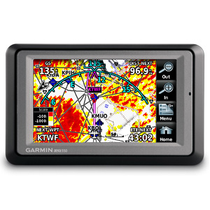
Garmin aera 510 Stepping up from Garmin's base model aera 500, the 510 version adds support for NEXRAD imaging and all the other great XM WX™ satellite weather capabilities¹. Plus, you can use the XM Radio capability to enjoy 170+ channels of digital music, news and other programming through your headset or cabin audio system. (The GXM 40 smart antenna is included with your aera.) In addition to the XM satellite access, the aera 510 comes fully preloaded with detailed aerial mapping of terrain contours and structural features. So, you'll have a wealth of information resources at your fingertips, to help you make better flying decisions. What's more, the simplicity of a single integrated cabling solution for power, music and datalink weather antenna options makes for easy, clutter-free aera connectivity in the cockpit. |
|
Garmin aera 500 There are four aera models in the Garmin lineup, offering a full range of cost/capability choices. The first and most affordable unit in the series is the aera 500. Featuring a crisp 4.3-inch QVGA wide-format touchscreen and pre-loaded graphical mapping, this versatile, feature-rich unit comes ready for takeoff, right out of the box. |
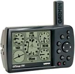 |
Garmin GPSMAP 196 This WAAS-capable unit has detailed moving map graphics, HSI steering guidance, a Jeppesen database, and all the other pilot-friendly features you'd expect from Garmin. You'll be amazed at the exceptional resolution and contrast on this unit's 12-level grayscale display, and its lightning-fast processor makes for extremely fast map redraws and scrolling. Click here for more Info!
|
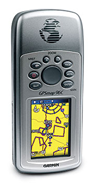 |
The portable, color GPSMAP® 96C, along with GPSMAP 96, integrate full-featured GPS navigation with a Jeppesen database and comprehensive towers-and-obstacles database — giving pilots the freedom to go anywhere.Click here for more Info! |
Pilots Haven Inc.©2003-2011
(KFRG) 7150 Republic Airport Room 101 Farmingdale, New York 11735 USA
Toll Free 1.800.749.8119 Fax 1.631.777.7787 E-mail info@pilotshaven.com