
 |
|
||||||||
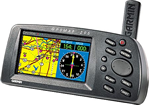
Mapping details on Garmin's GPSMAP 295 provide a clear picture of the ground below. Its big, 4-inch (diagonal) 16-color display makes it easy to distinguish SUAs from highways, or VORs from nearby towns. Move the cursor to one of those SUAs and the name, controlling agency, and vertical boundaries pop-up on the map. Meanwhile a "vector to final" feature offers the finest situational awareness on approach. This unit also can provide position accuracy to less than three meters when receiving WAAS corrections. Like all Garmin portables, the GPSMAP 295 is pilot configurable. You can split the screen to keep an eye on an HSI graphic while tracking your progress on the moving map. You can also store up to 30 locations in a personal favorites list for quick access to those frequently traveled spots. Installation options are equally handy. Mount the 295 on the yoke for convenient one-thumb operation, or attach it to the glareshield in a heads-up configuration. Your choice. Since the GPSMAP 295 is CD-ROM compatible, you also enjoy virtually unlimited mapping utility. Load city-specific data into your GPSMAP 295 from a MapSource® CD accessory, transfer the unit to your car, and you'll navigate to a restaurant on the ground as easily as you follow a flight plan in the air. The GPSMAP 295—brilliant GPS innovation. See it at a dealer (or cockpit) near you.
| ||||||||
Package includes:
Plotter/Moving Map Features Database: Built-in Jeppesen®; includes worldwide airports and VORs, plus Americas, or Atlantic International, or Pacific International NDBs, Intersections, special use and controlled airspace, runway data, plus airport, FSS, and ARTCC frequencies. Data Cartridges : Accepts preprogrammed data cards for detailed coverage of Canada East, Canada West and Alaska Metroguide. Navigation Features Waypoints:
Routes: 20 reversible with up to 30 points each, plus TracBack® Performance Receiver: PhaseTrac12™, 12 parallel channel receiver continuously tracks and uses up to 12 satellites to compute and update position
Accuracy:
Interfaces: NMEA 0183, Proprietary Garmin to Garmin panel mount products Temp. Range: 5°F to 158°F (-15°C to 70°C) Physical Size: 3.2"H x 6.8"W x 2.6"D (8.0 x 17.3 x 6.5 cm) Power Source: 10-35 vDC or 6 AA alkaline batteries |
||||||||
Pilots Haven Inc.©2003
5507-10 Nesconset Highway Unit 163 MT. Sinai NY 11766
Toll Free 1.800.749.8119 Fax 1.877.853.6240 E-mail info@pilotshaven.com