Package includes:
- GPS III® Pilot receiver
- Basemap:
Americas Land or
International Land
- Built-in Jeppesen® Database
- Dash mount
- Owner's manual
- Quick reference guide
- Wrist strap
Plotter/Moving Map Features
Database: Built-in Jeppesen®; includes Americas, Atlantic International, or Pacific International Airports; VORs; NDBs; intersections, special use and controlled airspaces; runway data, plus airport, FSS, and ARTCC frequencies
Basemap: Americas Land or International Land basemap; includes: state/country boundaries, lakes, rivers, railroads, cities, coastlines, US state and interstate highways, and local thoroughfares
MapSource®: Trip and Waypoint management functions are compatible with most Garmin® MapSource products.
Plotting Scales: 500-foot to 5,000-mile screen with push-button zoom control
Navigation Features
Waypoints:
- Total: 500 each with name, comment, symbol, and map diplay options
- Nearest: 9 (automatic) continuously updated
Routes: 20 reversible with up to 30 waypoints each, plus TracBack®
Map Datums: Over 100
Performance
Receiver: Differential-ready 12 parallel channel receiver continuously tracks and uses up to 12 satellites to compute and update a position
Acquisition Times:
- Warm: approx. 15 seconds
- Cold: approx. 45 seconds
- AutoLocate®: approx. 5 minutes
Update Rate: 1/second, continuous
Accuracy:
- Position: 1-5 meters (3-15 feet) with DGPS. RMS
- Velocity: 0.1 knot RMS steady state
Dynamics: 6g's
Interfaces: NMEA 0183, RTCM 104 DGPS corrections and proprietary Garmin for all Garmin panel mounts, PC interface kit, and database updates
Antenna: Detachable with standard BNC connector
Physical
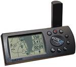
Size: 2.32"H x 5"L x 1.62"W (5.9 x 12.7 x 4.1 cm)
Weight: 9 ounces (255g) with batteries
Display: 2.2"W x 1.5"H (5.6 x 3.8 cm) high-contrast electro-luminescent backlit FTN display; switchable orientation
Power
Source: 10-32 VDC (4 AA alkaline batteries)
Usage: 0.75 watts
Battery life: up to 10 hours
Memory: Internal lithium battery backup lasts up to 10 years |